

Submitted by Xu Zhang
Objectives:
Content:
Students will:
- Activate their own schemata of the target country and city;
- Familiarize themselves with the map of China, its terrain and administrative areas;
- Locate the major cities in central, east, and south China;
- Describe the geographical location of Beijing in relation to the whole country and to the major cities.
Cultural:
Students will:
- Activate their own schemata of the target culture;
- Raise their awareness of what most Mainland Chinese consider to be "China" (alternative perspective awareness);
- Understand how the Chinese categorize the geographical areas of the country;
- Understand the present-day Chinese concept of directions
Language: Content Obligatory
Students will:
- Use the following words and phrases (see attachement: word list lesson 1, list 1)
- Use the following grammatical structures (see attachment: grammar list lesson 1: list 1)
Language: Content Compatible
Students will:
- Use a more informal register to play a game "I am (a city), s/he is (a city)" to internalize the phrases and structures for direction;
- Use the academic descriptive register of the language in its presentational mode to describe the geographical location of Beijing;
- Use appropriate and polite language to request information.
Learning Strategies / Social and Skills Development:
Time Frame:
1.5 hours
Materials Needed:
(all available in the "Attachments" section below)
- Blank transparencies
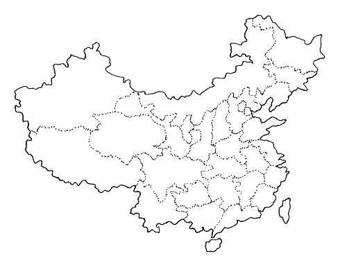
- A blank map of China in transparency; handouts of blank maps of China
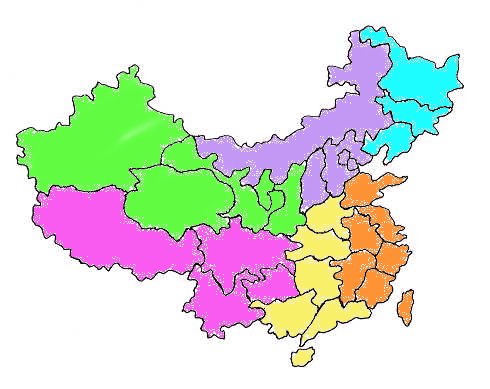
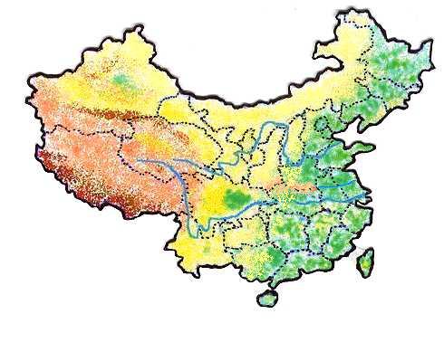
- An administrative map of China, and a relief map of China; and handouts of both maps
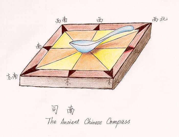
- Paper imitation of a modern compass with moveable hands; (miniature of an ancient Chinese compass if possible)
- Enough computers linked to the World Wide Web (if applicable); or teacher-created handouts printed from the web on general information about Beijing and China
Description of Assessment (Performance Project):
Context: The students, after studying in school for a substantial number of years, should have sound knowledge of the map of the world, the territory of the earth's continents and oceans, and a clear idea of where major countries in the world locate. They are expected to be reasonably competent map-readers. The Mainland Chinese prefer to call their political maps "administrative maps", and these lesson plans will follow their tradition.
Pre-task: What do you know about China/Beijing, the geography and the Chinese culture?
This task is the pre-task of the lesson and of many of the following lessons. Time spent on this activity will depend on the extent to which the students know about the target country. Generally speaking, this should take less than 5 minutes.This acitivity is designed a whole class activity. The teacher has the overhead projector and the blank transparencies ready and asks the students the pre-task question. The students then share whatever they know while the teacher writes all the answers down on the transparencies for later use. Students are encouraged to answer in Chinese. When they have difficulty expressing themselves in the target language, they are allowed to speak in English or in a mixture of Chinese and English. At the same time, the teacher gains a general impression of the students' language proficiency and content as well as cultural knowledge.
As a wrap-up of this pre-task activity, the teacher highlights with a different color the answers related to the topic of the lesson while at the same time reiterate in Chinese as much as possible these answers.
Task set-up: The map of China
Step 1: Pair work. Teacher has a large relief map of China ready to share with the class. The students are to discuss with a partner the most characteristic terrain shapes of the country, the names of the two largest rivers, and the name of the biggest basin. As the pairs discuss, the teacher visits the pairs in class to listen to their discussions, to solve their problems, and to make sure that the students are using a reasonable amount of Chinese in accordance with their proficiency levels. As a feedback, the teacher selects at random three pairs to tell the class their answers to one of the three questions in as much Chinese as possible. Other pairs may correct add their own observations or suggestions on the content/language. In the course of this pair report, the teacher writes on board the students' unknown words/phrases. A suggested list is in the attachemnt, word list lesson 1, list 2.Step 2: "Directions"
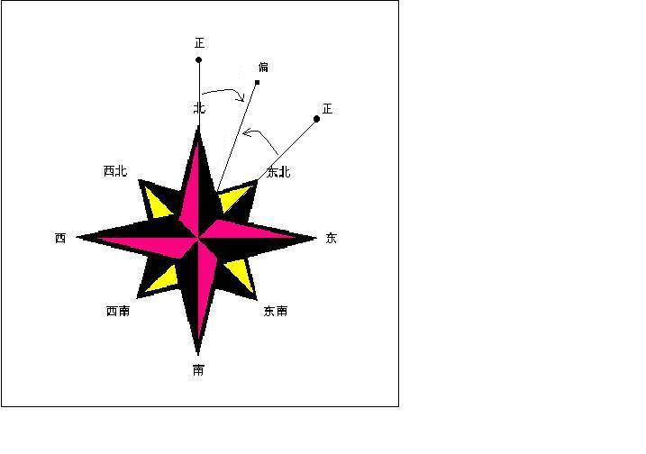
Ask the students "if you are out in the wild, which tool can help you tell directions?" Then the teacher introduces the Chinese word for compass. At the same time, the teacher brings out the paper-made blank imitation compass and work with students to mark directions on it in Chinese, etc. Then the teacher introduces the Chinese concept of middle/center, and the fact that in history, the Chinese viewed themselves as dwelling in the middle of the world and how this influenced their delineation of their land even today. At this stage this piece of cultural information is just for the students' later better understanding of the content area knowledge and the culture. Students are not expected to produce any language other than the directions themselves.Step 3: Listening activity
The students listen to an audio clip in which a native speaker of Chinese is presenting on how the Chinese categorize their territory -- South China, North China, the Middle, the East, and the West of the Mainland. The presentation is in lecture speed, which is relatively slow and clearly articulated. Each student is given a wordlist and a copy of the relief map of the country on which all the suggested (in the audio) geographical landmarks are presented. The students are to listen to the tape recording and to mark on their maps the delineated territories while at the same time write in the names they have heard. The students are to listen for three times. Before listening, the teacher should briefly draw a link between the directions the students just learned and the word hua. The first time they will just listen and get a general idea of the presentation. The second time they will be marking and filling out the map with the help of the wordlist. The words/phrases they are to use are listed in the attachment, word list lesson 1, list 3.The third time they are to check what they have done, add to it, or make corrections. Then, they are asked to compare their results in groups of four and try to reach an agreement among group members. After their comparison, each group is to choose a representative to go to the front and mark on the teacher's map the part the teacher wants them to mark. The rest of the class is to evaluate their markings together with the teacher.
During task:
Find the location of Beijing and talk about the directional relationship between Beijing and other major cities in ChinaStep 1: The Location of Beijing
Teacher has the transparency of a blank map of China readily projected through the overhead and then has one student go up to the overhead to point out the location of Beijing. If it is wrongly located, a volunteer may be asked to point it out. Then the handouts of the blank map of China are distributed to students who will mark the location of Beijing with an asterisk. Then the teacher asks what other cities in China that the students have heard of and to tell the class the locations if they know. To summarize by using the administrative map, the teacher asks the students to mark on their blank map with a dot the major cities in China following him/her.Step 2: Pair work
The teacher asks the students to talk in pairs about the directional relationship between Beijing and the other major cities in China by using the directions and the territorial divisions they have just learned in Chinese. As the pairs are doing the activity, the teacher goes round the classroom to monitor.
- Words and Phrases Used (except for Beijing and Shanghai, other words are all sight vocabulary for the students) (please see attachment, word list lesson 1, list 4).
- Grammar Points (see attachment, grammar list lesson 1, list 2)
Students are reminded of paying attention to different registers of the language when they speak.
Step 3: Game -- "I am /(s)he is (city/territory name)"
The students are to personify the cities or territories. They are to imagine themselves to be the cities or the territories in China. It begins like: the first student says, "I am Beijing." Then s/he selects another student in class and says, "s/he is (city/territory name)". Next, the starter comments on his/her spatial relationship with the "city" she selected according to the map of China. The selected person then takes the turn and does the same thing. And the activity goes on until the last person has had a turn. This activity is to add more fun and automaticity to their acquisition of spatial relationship words and the related sentence patterns. If the learners are young learners, the teacher may also consider making them stand up and move to the right position as if in the map. The teacher, at this stage, is using an informal evaluation sheet to mark the students' performance and their difficulties (some maybe solved on the spot, others are to be solved later at the feedback stage). The evaluation sheet is in the attachment, assessment lesson 1, assessment 1.Feedback after the game. The teacher summarizes and points out the language use students should pay attention to.
Step 4: Chain presentation
The students are to use the presentational mode and register of the language to present to the class as in a chain. The teacher has students draw lots to be assigned a city or a territory to present to the whole class -- on its relative directions and spatial relationship. The order of the presenting students should follow the spatial relationship on the map which they feel logical or comfortable with. While one student is presenting, the other students are to listen carefully and to ask questions related to the city/territory's spatial relationship (such as those the presenter forget to touch upon) in Chinese. Questions should be asked and answered politely and appropriately as in a real class presentation. The teacher, as the students are presenting, should mark on the evaluation sheet suggested as in the attachment, assessment lesson 1, assessment 2.Post-task: After class the students are to make a paper compass and mark the directions on it. They are also to write a report on the geographical location of Beijing as the beginning part of their class project report in Chinese in the formal style. These asks are to be examined and evaluated by the teacher in the next lesson.
Extensions:
Personal: The students are encouraged to surf the web and to gather more information about the geographical location of Beijing as well as other major cities. They are also encouraged to print out maps that interest them and share them with class members, either formally or informally. Students are also encouraged to write a letter to their friend in Chinese about what they have learned in lesson one.
Assessment:
Embedded in the tasks.
References and Resources:
http://www.theodora.com/maps
http://www.beijing.com
http://www.china.com
http://www.yahoo.comSit, V. (1995). Beijing. John Wiley & Sons, Ltd.: Chichester, NY, Brisbane, Toronto, Singapore.
Attachments:
NOTE: some attachments are in PDF form (get Acrobat Reader)Word list Lesson 1 (list 1 through 4)
Grammar lists Lesson 1 (list 1 and 2)
Assessment Lesson 1 (assessment 1 and 2)
Blank China map
Administrative China map
China relief map
Compass
Compass 2